
Typhoon Uwan Gains Strength as it Approaches Eastern Visayas
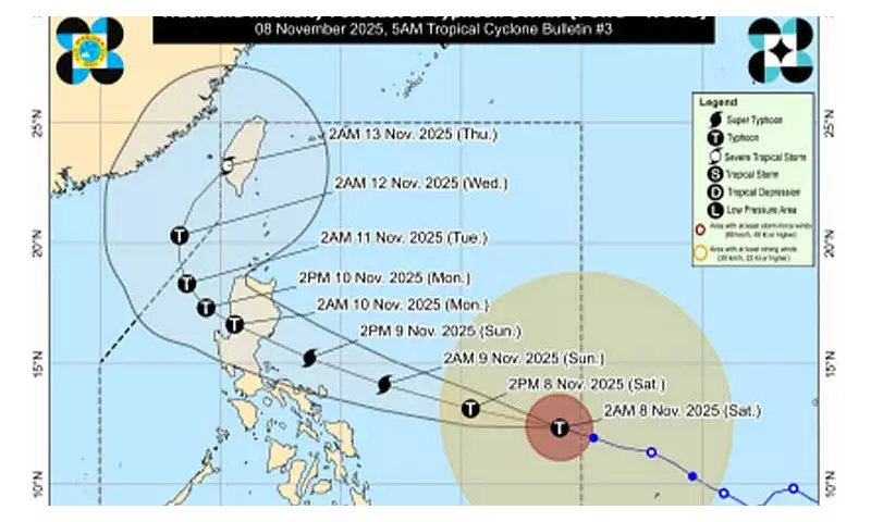
The Philippine Atmospheric, Geophysical and Astronomical Services Administration (PAGASA) reported on Saturday that Typhoon Uwan, known internationally as Fung-Wong, has further intensified while moving east of Eastern Visayas. According to the weather bureau's 5 a.m. bulletin, the typhoon's center was positioned approximately 985 kilometers east of Eastern Visayas, tracking west-northwestward at a speed of 25 kilometers per hour.
The storm currently packs maximum sustained winds of 130 kilometers per hour near its center, with gustiness reaching up to 160 kilometers per hour. PAGASA forecasts that Uwan will continue moving west-northwestward until Monday before shifting to a general north-northwestward direction by Tuesday.
Storm Signals Raised Across Multiple Regions
PAGASA has raised Tropical Cyclone Wind Signal No. 2 over several areas including Catanduanes, specific portions of Northern Samar, northeastern Samar, and northern Eastern Samar. The affected municipalities in Northern Samar include Lope de Vega, Palapag, Las Navas, Mapanas, Laoang, Catubig, Mondragon, Lapinig, Pambujan, Catarman, San Roque, Silvino Lobos, and Gamay.

Meanwhile, Signal No. 1 has been hoisted over extensive areas across Luzon, Visayas, and parts of Mindanao. In Luzon, this includes Cagayan (including Babuyan Islands), Isabela, Quirino, Nueva Vizcaya, Apayao, Abra, Kalinga, Mountain Province, Ifugao, Benguet, Ilocos Norte, Ilocos Sur, La Union, Pangasinan, Aurora, Nueva Ecija, Bulacan, Tarlac, Pampanga, Zambales, Bataan, Metro Manila, Cavite, Laguna, Batangas, Rizal, Quezon (including Polillo Islands), Camarines Norte, Camarines Sur, Albay, Sorsogon, Masbate (including Ticao Island and Burias Islands), Marinduque, Romblon, Oriental Mindoro, Occidental Mindoro (including Lubang Islands), and Calamian Islands.
In the Visayas region, Signal No. 1 covers the remainder of Northern Samar, Samar, and Eastern Samar, along with Biliran, Leyte, Southern Leyte, northeastern Bohol, northern and central Cebu (including Bantayan and Camotes Islands), northern Negros Occidental, northern and central Iloilo, Capiz, Aklan, and northern and central Antique (including Caluya Islands). Mindanao areas under Signal No. 1 include Dinagat Islands and Surigao del Norte.
Landfall Projection and Intensity Forecast
Based on the current track forecast, Typhoon Uwan is expected to make landfall over the southern portion of Isabela or the northern portion of Aurora late Sunday evening or early Monday morning. The weather bureau warns that Uwan is forecast to rapidly intensify and may reach super typhoon category by Saturday or Sunday morning.
PAGASA indicates the typhoon may make landfall at or near its peak lifetime intensity. After crossing land, the storm will traverse the mountainous terrain of Northern Luzon and is projected to emerge over the West Philippine Sea on Monday morning or afternoon. While interaction with the terrain will cause Uwan to weaken, it is expected to maintain typhoon status throughout its passage over Northern Luzon and the West Philippine Sea.
Weather Impacts and Safety Warnings
Stormy weather conditions are forecast over Catanduanes, Northern Samar, and Eastern Samar. PAGASA has issued warnings about potential flash floods and landslides in these areas due to moderate to heavy rains, which may at times become intense, caused by Typhoon Uwan.
Central Visayas, the rest of the Bicol Region, the remaining parts of Eastern Visayas, Isabela, Aurora, Quezon, Dinagat Islands, and Surigao del Norte will experience rains and gusty winds. The rest of the country can expect cloudy skies with scattered rains and thunderstorms.
Moderate to strong winds and moderate to rough seas will prevail throughout the entire archipelago, according to PAGASA's latest advisory. Residents in affected areas are advised to monitor updates regularly and follow evacuation orders from local authorities.


