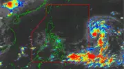
Tropical Storm Strengthens East of Luzon
A tropical storm east of Southeastern Luzon intensified with 85 kph winds and is moving westward at 20 kph. PAGASA monitors its possible entry into PAR in the coming days.

A tropical storm east of Southeastern Luzon intensified with 85 kph winds and is moving westward at 20 kph. PAGASA monitors its possible entry into PAR in the coming days.
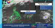
A tropical depression east of the Philippines may intensify into a typhoon. It is currently outside PAR but being monitored.

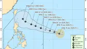
The low pressure area outside PAR has developed into a tropical depression. Pagasa expects it to enter PAR on June 20, possibly named Francisco, with winds up to 55 kph.

The low pressure area outside PAR has developed into a tropical depression. It will enter PAR on Saturday and be named Francisco, possibly intensifying into a typhoon by Sunday.

Shared lists with real-time sync. No signup needed — just open and shop together.
Recommended
Most of the Philippines will experience isolated rain showers due to thunderstorms on Monday as over 26 million learners return to school. The southwest monsoon brings scattered rains in Ilocos Region and Zambales.

Pagasa announces the start of Habagat season. Typhoon Domeng continues to enhance monsoon rains across the western Philippines, including Metro Manila and Visayas.

The Philippine Atmospheric, Geophysical, and Astronomical Services Administration (Pagasa) announced the official start of the Habagat or Southwest Monsoon, signaling the beginning of the rainy season in the country.

Pagasa announces start of Habagat on May 30. Cebu and Central Visayas will experience fair, hot weather with localized thunderstorms, while Typhoon Domeng enhances monsoon rains in western Philippines.

PAGASA says the southwest monsoon (habagat) may begin late May or early June, but this does not mark the start of the rainy season, which is expected in early June.
Shared lists with real-time sync. No signup needed — just open and shop together.
Recommended
PAGASA reports scattered rains and thunderstorms in parts of Luzon, Visayas, and Mindanao due to southwesterly wind flow and a tropical depression trough.

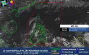
A tropical depression is moving toward the Philippine Area of Responsibility, with winds up to 55 km/h. It may enter PAR in coming days, affecting Mindanao and Visayas.

The low pressure area outside PAR may develop into a tropical storm named Domeng, bringing rains and triggering the southwest monsoon across parts of the Philippines.

With Pampanga's heat index reaching 44°C, learn about heat stroke dangers, symptoms, and essential prevention tips to stay safe during extreme heat.
PAGASA reports three weather systems, including an LPA, will bring isolated rains across the Philippines on Sunday, with 39 areas under danger-level heat indices.
Shared lists with real-time sync. No signup needed — just open and shop together.
Recommended
The trough of a low-pressure area and easterlies will bring scattered rains and thunderstorms over most parts of the Philippines, PAGASA said.

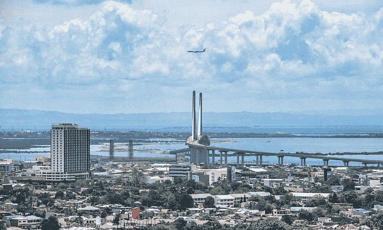
Pagasa reports Cebu will experience fair weather with isolated thunderstorms, but the heat index is expected to reach 42°C, entering the danger zone where heat stroke is probable.

Most of the Philippines will have fair weather on May 17, but northern Luzon and Mindanao face scattered rains. Heat index may reach 46°C in Dipolog, with 41 areas under danger level.

Pagasa is monitoring two low pressure areas, including former tropical depression Caloy, but both are unlikely to affect the Philippines' weather or develop into cyclones.

Cebu will continue experiencing hot and humid weather with heat index up to 39°C, Pagasa says. El Niño alert remains; public advised to avoid prolonged sun exposure.
Shared lists with real-time sync. No signup needed — just open and shop together.
Recommended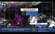
Tropical Storm Caloy enters PAR but has no direct impact. Easterlies bring warm, humid weather. Heat index danger level in 26 areas, with Dagupan at 44°C.
A low pressure area was spotted east of Northeastern Mindanao, while a tropical depression outside PAR is being monitored for possible entry and weather changes.

Pagasa forecasts near-normal rainfall across Mindanao for May 2026, with above-normal precipitation possible in western areas like Zamboanga Peninsula and BARMM.

Pagasa says Easterlies will continue affecting most of the Philippines, bringing scattered rains and thunderstorms, with possible flash floods or landslides.

The easterlies will cause warm and humid conditions nationwide on Thursday, with scattered rains and thunderstorms in several areas, PAGASA reports.
Shared lists with real-time sync. No signup needed — just open and shop together.
Recommended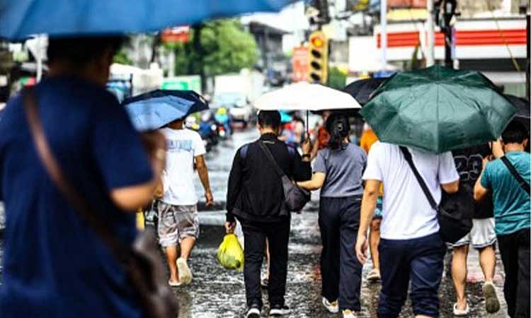
Pagasa reports easterlies affecting the country, bringing scattered rains and thunderstorms over several Mindanao areas, with possible flash floods or landslides.

PAGASA forecasts hot and humid weather across the Philippines due to easterlies, with scattered rains and danger-level heat indices in several areas.
Cebu's heat index hit 39°C on April 26, 2026, prompting Pagasa to warn of extreme caution and heat-related risks. Residents urged to stay hydrated and limit outdoor activities.
Cebu faces hotter days ahead with heat index peaking in May, possibly reaching 40°C, Pagasa warns. Extreme caution category prompts safety measures.

Cebu residents are modifying daily schedules as Pagasa reports heat index levels between 33°C and 36°C, with Bohol experiencing higher readings of up to 37°C.
Shared lists with real-time sync. No signup needed — just open and shop together.
Recommended
PAGASA reports easterlies affecting southern Luzon, Visayas, and Mindanao, bringing partly cloudy to cloudy skies with isolated rainshowers or thunderstorms on Friday.
