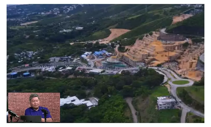
Former Cebu City Planning and Development Office director Joseph Michael Espina has issued an urgent warning about the controversial Monterrazas de Cebu development, stating it now faces an immediate landslide threat following the Department of Environment and Natural Resources work stoppage order.
Exposed Excavations Create Dangerous Conditions
Espina explained to SunStar Cebu on Monday, November 24, 2025, that the DENR's work stoppage order has left large, excavated sections of the mountainside exposed and completely vulnerable. The project had already carved out a significant portion of the mountainside, yet no stabilization measures are currently in place to protect the terrain from potential collapse.
"So there has to be interventions or mitigating measures now to address the open areas there. So I don't know if they will be allowed to cover it up. I don't know how they can do that," Espina stated during his interview.

The situation becomes even more critical with incoming severe weather. The Philippine Atmospheric, Geophysical and Astronomical Services Administration reported that tropical depression Verbena is expected to hit Cebu Island by midnight Monday, bringing another cycle of intense, erratic rainfall that could trigger landslides on the unstable terrain.
History of Flooding and Regulatory Action
The Monterrazas development has drawn intense public and regulatory scrutiny due to reported severe flooding in Barangay Guadalupe and adjacent Cebu City barangays, which the development allegedly contributed to. The regulatory action was prompted by events during typhoon Tino on November 4, when a viral video surfaced showing swift runoff water and a damaged water retention pond at the construction site.
Following these incidents, the DENR issued a notice of violations and a stoppage order to Monterrazas de Cebu on November 12, effectively halting all operations. The Cebu City Government and the DENR launched separate investigations, while the matter was also brought up at the Senate Blue Ribbon Committee hearing on flood control anomalies on November 14.
In response to the growing controversy, the Barangay Council of Guadalupe issued a resolution calling for a technical inspection of the development's retention ponds and drainage systems, urging a full probe by City Hall, DENR and the Mines and Geosciences Bureau.
Project Details and Environmental Compliance
Espina provided details about the project's current infrastructure, noting that Monterrazas currently has eight existing detention ponds designed to store runoff water and control flooding. Developers had planned to increase the total to eleven units across the massive 200-hectare lot intended for green areas, commercial spaces, and residential use.
The former planning director confirmed that the Monterrazas development, including its phase "The Rise," complied with its Environment Compliance Certificate and other DENR requirements, which were prerequisites for the Zoning Board's approval. The CPDO issued the developer location clearance after verifying this compliance, and developers have been issued at least two ECCs, the latest being an updated version in 2024.
Espina pointed out that the project was allowed under the 1996 zoning ordinance since the area was classified as a residential zone. Even with an 18-degree slope, development is not prohibited when paired with proper engineering interventions. However, he found it contradictory that the DENR, the same agency that issued the ECC allowing the project, was now taking action against the developer.
Regarding recent flooding in other areas, Espina clarified that the Monterrazas project drains to the Kinalumsan watershed, not the Mananga or Butuanon Rivers. Therefore, the development had no direct link to the deadly and devastating flash floods in Talisay, Mandaue, Consolacion and Liloan. Nevertheless, he emphasized that the alleged violations at Monterrazas remain serious and require immediate attention.

During typhoon Tino, rainfall levels in upland areas reached as high as 300 millimeters due to the orographic effect—equivalent to a month's rain in a single day. The hardest-hit areas in the city lie along the Mananga and Butuanon basins, which serve as the largest watersheds and downstream channels for the most intense rainfall. Cebu City has seven main watersheds: Butuanon, Mananga, Lahug, Guadalupe, Kinalumsan, Buhisan and Mahiga.