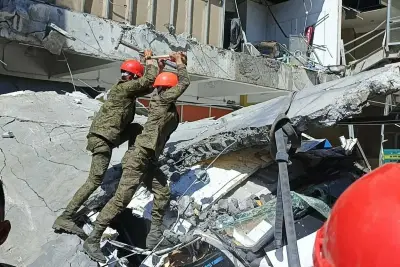
Urban growth is often a sign of economic progress, but in Cebu City, recent catastrophic events suggest that expansion has dangerously exceeded the land's natural limits. The severe damage caused by typhoon Tino, internationally known as Kalmaegi, has brought a critical issue back into the spotlight: have decades of exceptions to zoning rules created a permanent threat to residents?
Petition for a Complete Zoning Review
A coalition of citizens, urban planners, and environmental advocates is urgently calling on the Cebu City Council to accelerate a full reassessment of the city's Comprehensive Land Use Plan (Clup) and zoning ordinances. The group, led by urban policy advocate Gus Agosto, submitted a formal letter and a draft resolution to Mayor Nestor Archival, Vice Mayor Tomas Osmeña, and the City Council.
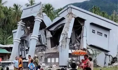
Their central argument is clear: communities have been left dangerously vulnerable to disasters due to obsolete regulations and uncontrolled development in upland areas. The massive floods and slope failures that occurred on November 4, 2025, did more than showcase nature's power; they revealed profound structural flaws in the city's decision-making process for safe construction zones.

Outdated Maps and Unchecked Development
The heart of the problem lies in the data guiding the city's growth. Agosto points out that the current zoning maps are based on information from 1996, which was carried forward into revisions made in 2025. These old maps frequently fail to represent the true state of today's terrain and watershed systems.
This discrepancy has allowed development to spread into areas that are naturally unsuitable. A key piece of data underscores the issue: the Japan International Cooperation Agency (Jica) Roadmap for Sustainable Urban Development in Metro Cebu (2015–2050) identified a mere 365 hectares of non-hazardous land within Cebu City fit for development.
Despite this stark limitation, the conversion of agricultural and forested land has proceeded rapidly. Reports indicate that since 1996, approximately 300 hectares in Cebu City—and over 6,000 hectares across Metro Cebu—have been changed to built-up use, often ignoring the warnings in contemporary studies.
The Dangerous Role of Zoning Variances
Zoning laws are designed to control land use, but "variances" permit developers to sidestep these restrictions. The coalition contends that the City Zoning Board's routine approval of such variances since the 1990s opened the door for numerous conversions on hillsides.
Agosto pointed to specific large-scale projects, including Monterrazas de Cebu in Barangay Guadalupe and quarrying operations in Barangay Pulangbato. The group directly connects these projects to altered natural drainage patterns that intensified the flooding from typhoon Tino.
"We could tell that Tino flooding was man-made due to the variance," Agosto stated. The problem extends beyond the uplands. The narrowing of rivers, encroachment on easements, and the building over of drainage channels have all worsened flooding downstream.
Immediate Reforms Demanded
The coalition, which includes groups like Paglaum sa Sugbo, Seed4Com, and Justice for Cebu, is pushing for concrete changes to avert future disasters:

- A Full Review: A complete overhaul of the Clup and zoning rules to incorporate updated hazard and watershed data.
- A Moratorium: An immediate freeze on new upland and reclamation projects until proper safeguards are established.
- Updated Governance: Reforming the zoning board to include government agencies and civil society, ensuring policies match on-ground realities.
- Unified Management: Creating a single watershed management authority to clarify jurisdiction between national and local agencies.
The petition is now with City Hall, where councilors have received the proposals. The coalition views this as a result of persistent public pressure for accountability. If the City delays action, the matter may move from the council hall to the courts. The group is prepared to file a Writ of Kalikasan, a legal remedy for environmental damage affecting life and property across multiple localities, as a final recourse if local governance reforms fail.