An environmental planner has raised critical questions about the consistency of Cebu City's urban development policies, particularly focusing on why watershed protection measures weren't implemented when architect Joseph Michael Espina served as the city's planning coordinator.
Questioning Past Implementation
Augusto B. Agosto, an environmental planner and real estate consultant, responded to Espina's recent interview advocating for Metro Cebu to adopt the Japan International Cooperation Agency's 2015 watershed-based development framework. While acknowledging the importance of Espina's call for green belts, green loops, floodplain restoration and watershed protection, Agosto pointed out what appears to be a significant contradiction.
During Espina's three-year tenure as Cebu City planning coordinator, he had direct influence over the Comprehensive Land Use Plan, zoning policies and upland development controls—the very tools that could have institutionalized the interventions he now recommends. The public deserves clarification, Agosto argues, on why watershed-based zoning, upland conservation rules, green-belt protection mechanisms and relocation land-banking weren't initiated when Espina had the authority to implement them.

Concerning Land Use Changes
Actual land use and zoning shifts under Espina's leadership show movement away from the Jica model rather than toward it. According to City Planning and Development Office GIS data comparing 2020 existing land use with proposed 2023–2032 zoning:
Forest lands decreased dramatically from 9,312 hectares to just 2,892 hectares, representing a loss of 6,419 hectares of crucial forest cover.
Agricultural land declined from 13,322 hectares to 3,653 hectares, a staggering reduction of 9,668 hectares that threatens food security and environmental stability.
Meanwhile, commercial zoning more than doubled—expanding from 983 hectares to 2,038 hectares, with much of this growth occurring in upland barangays including Guadalupe, Banawa, Kalunasan, Lahug–Busay, Tisa, Buhisan, Pardo, Budlaan and Pulangbato.
Development Pressures Continue
The data reveals additional concerning trends in Cebu City's urban development pattern. Residential zones decreased by 183 hectares, while socialized housing remains at only 318 hectares—roughly 1.06 percent of Cebu City's total land area, far too small to support long-term relocation needs.
Industrial land saw only modest growth, increasing from 43 hectares to 122 hectares, falling far below Jica's recommendations for economic decentralization and balanced urban growth. Despite repeated hazard warnings, several flood-prone lowland areas continued to experience development pressure.
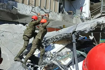
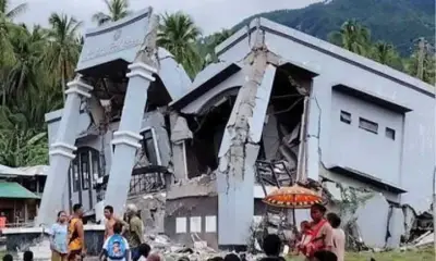
These zoning choices and the absence of necessary safeguards have shaped the city's vulnerability long before typhoon Tino, whose destruction revealed the consequences of weakened uplands, reduced natural buffers and development encroachment into high-risk zones.
As Cebu rebuilds from typhoon Tino's devastating impacts, public discourse must include not only forward-looking solutions but also a clear understanding of prior planning decisions and their consequences. Accountability, consistency and transparency remain essential if Cebu's future land-use direction is to be truly science-based, safety-oriented and resilient.