
Super Typhoon Uwan Intensifies Over Bicol Region
The Philippine Atmospheric, Geophysical and Astronomical Services Administration (Pagasa) issued grave warnings Sunday afternoon as Super Typhoon Uwan continued to pose life-threatening conditions across the Bicol Region. The powerful storm maintained its west northwestward trajectory over the coastal waters of Camarines Norte, packing destructive winds and threatening multiple provinces.
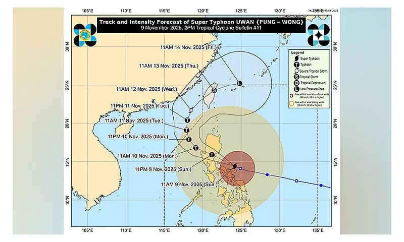
As of 1 p.m. on Sunday, November 9, 2025, weather monitors located the typhoon's center approximately 135 kilometers north northwest of Virac, Catanduanes, or about 100 kilometers northeast of Daet, Camarines Norte. The super typhoon demonstrated alarming strength with maximum sustained winds reaching 185 kilometers per hour and powerful gusts accelerating to 230 km/h.
Critical Warnings and Forecasted Path
Pagasa emphasized that residents should not focus solely on Uwan's center track, noting that dangerous conditions could extend far beyond the predicted path. The weather bureau specifically warned that heavy rainfall, severe winds, and storm surges might impact areas outside the forecast confidence cone.

The typhoon is projected to maintain its west northwestward movement throughout the next 24 hours. According to Pagasa's latest bulletin, Uwan will pass close to Calaguas and Polillo Islands during Sunday afternoon or evening before making landfall at or near its peak intensity over Aurora's central portion Sunday night or early Monday morning.
A direct hit over Calaguas and Polillo Islands remains possible due to the storm's proximity, meaning the eyewall could affect these areas without actual landfall occurring.
Signal Warnings and Affected Regions
As of 2 p.m. Sunday, Pagasa had raised Tropical Cyclone Wind Signal Number 5 across multiple areas including portions of Quirino, Nueva Vizcaya, Nueva Ecija, Aurora, Polillo Islands, Camarines Norte, Camarines Sur, and Catanduanes.
The extensive warning system also included:
- TCWS Number 4 across Isabela, Quirino, Nueva Vizcaya, Ifugao, Benguet, Ilocos Sur, La Union, Pangasinan, Aurora, Nueva Ecija, Zambales, Tarlac, Pampanga, Bulacan, Rizal, Quezon, Camarines Norte, Camarines Sur, Albay, and Catanduanes
- TCWS Number 3 covering parts of Cagayan, Isabela, Apayao, Abra, Kalinga, Mountain Province, Ifugao, Ilocos Norte, Ilocos Sur, Zambales, Bataan, Tarlac, Pampanga, Bulacan, Metro Manila, Cavite, Batangas, Rizal, Laguna, Quezon, Marinduque, Albay, Sorsogon, Ticao and Burias Islands, and Northern Samar
- TCWS Number 2 and TCWS Number 1 across additional Luzon provinces, Visayas regions, and parts of Mindanao
Long-Term Projection and Weakening Pattern
After making landfall, Uwan is forecast to traverse northern Luzon's mountainous terrain before emerging over Lingayen Gulf or the coastal waters of Pangasinan or La Union by Monday morning. While interaction with the terrain should cause significant weakening, Pagasa expects Uwan to maintain typhoon status throughout its passage across northern Luzon.
The typhoon will begin turning northwestward to northward from Monday to Tuesday, November 11, while remaining at typhoon category. By Wednesday, November 12, Uwan is projected to turn northeastward toward the Taiwan Strait while gradually weakening. The weather bureau forecasts landfall over western Taiwan on Thursday, November 13, followed by rapid weakening over Taiwan's landmass before emerging near Ryukyu Islands as a remnant low or weak tropical depression.
Pagasa continues to monitor Uwan's movements closely and urges all residents in affected areas to follow evacuation orders and stay informed through official channels as the dangerous weather system progresses.


