
The Philippine Atmospheric, Geophysical and Astronomical Services Administration (Pagasa) issued a critical warning to the public on Sunday morning, November 9, 2025, concerning the dangerous trajectory of Super Typhoon Uwan (international name: Fung-Wong).
Current Status and Movement
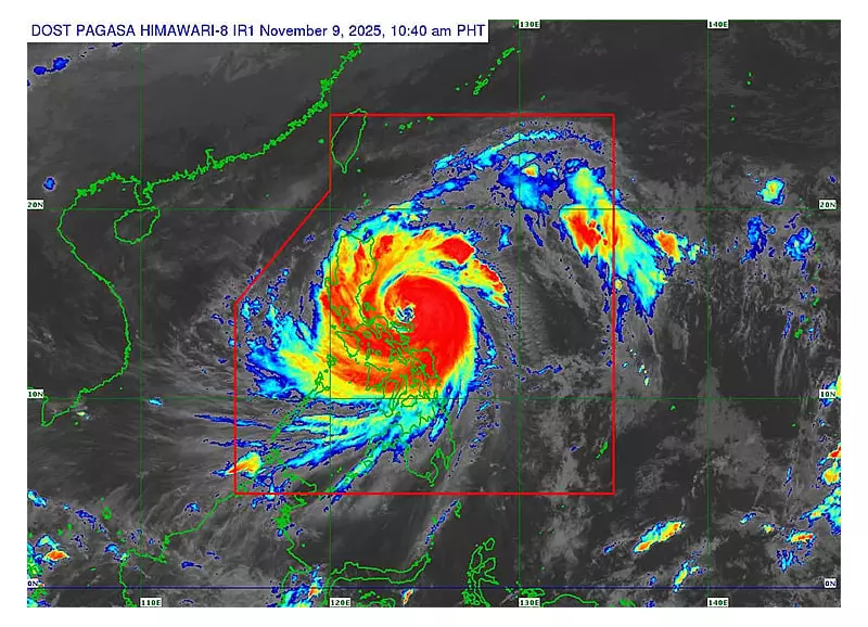
As of 10 a.m. Sunday, the eye of Super Typhoon Uwan was located over the coastal waters of Pandan, Catanduanes. The weather disturbance maintained maximum sustained winds of 185 kilometers per hour with powerful gusts reaching 230 km/h. The storm's central pressure was recorded at 935 hPa as it advanced west northwestward at 30 km/h.
Pagasa emphasized that typhoon-force winds could extend up to 800 kilometers from the center, creating hazardous conditions across a wide area. The state weather bureau specifically cautioned residents not to focus solely on the predicted center track, as the storm could still shift within the forecast confidence cone.

Projected Path and Landfall Expectations
According to Pagasa's forecast track, Uwan is expected to continue moving over Catanduanes coastal waters before passing close to Calaguas Islands on Sunday morning and Polillo Islands in the afternoon. The super typhoon is projected to make landfall at or near its peak intensity over the central portion of Aurora Sunday night or early Monday morning, November 10.
The weather bureau noted that due to Uwan's proximity, a direct hit from the eyewall remains possible over both Calaguas and Polillo Islands even without official landfall occurring in those areas.
After crossing Aurora, Uwan will traverse northern Luzon's mountainous terrain before emerging over Lingayen Gulf or the coastal waters of Pangasinan or La Union by Monday morning. While interaction with the mountains will cause significant weakening, Pagasa expects Uwan to maintain typhoon status throughout its passage over northern Luzon.
Tropical Cyclone Wind Signals in Effect
Pagasa has raised Tropical Cyclone Wind Signal (TCWS) Number 5, the highest warning level, over multiple areas including:
- Central portion of Aurora (San Luis, Baler, Maria Aurora, Dipaculao)
- Polillo Islands
- Northern portion of Camarines Norte
- Eastern portion of Camarines Sur
- Catanduanes
TCWS Number 4 remains in effect across parts of Isabela, Quirino, Nueva Vizcaya, Aurora, Nueva Ecija, Pampanga, Bulacan, Quezon, Camarines provinces, and Albay.
TCWS Number 3 covers extensive areas of Luzon including portions of Cagayan, Isabela, Nueva Vizcaya, Apayao, the Cordillera Administrative Region, Ilocos Sur, La Union, Pangasinan, Central Luzon provinces, Metro Manila, Calabarzon, Marinduque, Albay, Sorsogon, and Northern Samar.
Lower wind signals TCWS 2 and TCWS 1 are also in effect across numerous other provinces in Luzon, Visayas, and Mindanao, indicating the storm's widespread impact.
Pagasa stressed that heavy rainfall, severe winds, and storm surge may affect areas far from the landfall point or center track, including locations outside the forecast confidence cone. Residents in all affected regions are urged to continue monitoring official updates and follow evacuation orders from local authorities.


