The Philippine Atmospheric, Geophysical and Astronomical Services Administration (Pagasa) is closely monitoring Tropical Depression Ada as it gains strength over the Philippine Sea. The weather disturbance is expected to reach tropical storm category on Thursday, January 15, 2026, posing a threat to several regions in the eastern part of the country.
Current Location and Strength
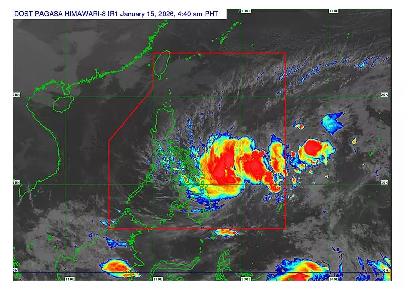
As of 4 a.m. on Thursday, the center of Ada was located approximately 385 kilometers east northeast of Hinatuan, Surigao del Sur. This is equivalent to about 465 kilometers east of Surigao City in Surigao del Norte. The storm is moving in a northwest direction at a speed of 20 kilometers per hour.
Pagasa reported that Ada is packing maximum sustained winds of 55 km/h near its center, with gusts reaching up to 70 km/h. The central pressure of the weather system is currently at 1000 hPa.

Areas Under Tropical Cyclone Wind Signal No. 1
In anticipation of strong winds, Pagasa has hoisted Tropical Cyclone Wind Signal (TCWS) Number 1 over multiple provinces. Residents in these areas should prepare for gusty conditions and potential rains.
The affected areas include:
- In Luzon: Sorsogon and the southeastern portion of Albay (Rapu-Rapu, Manito, Legazpi City).
- In the Visayas: Northern Samar, Samar, Eastern Samar, the eastern portion of Biliran, the eastern portion of Leyte, and the eastern portion of Southern Leyte.
- In Mindanao: Dinagat Islands, Surigao del Norte, and Surigao del Sur.
Pagasa warned that the highest wind signal likely to be raised during Ada's passage is TCWS Number 2.
Forecast Track and Potential Impacts
The state weather bureau forecasts that Ada will maintain a general northwestward track from Thursday through Sunday, January 18. A turn towards the north northeast is expected by Monday, January 19.
Based on the current forecast track, Ada is projected to pass close to Eastern Samar and Northern Samar either on Friday, January 16, or early Saturday morning, January 17. It is then expected to head towards the Bicol Region, making a close approach to Catanduanes by Sunday morning.
Pagasa cautioned that a further westward shift in its trajectory could result in a possible landfall over Eastern Visayas and the Bicol Region. This scenario would bring more significant impacts, including heavier rainfall and stronger winds.
Furthermore, the combined effects of the Northeast Monsoon and the outer circulation of Ada are expected to bring strong to gale-force gusts to several other areas on Thursday. These include Batanes, Babuyan Islands, Ilocos Norte, parts of Cagayan and Isabela, Aurora, Calabarzon, the islands of Lubang, Marinduque, Romblon, Mindoro, Cuyo Islands, the entire Bicol Region, and Central Visayas.
Residents in all affected areas are advised to monitor updates from Pagasa closely, secure loose outdoor items, and prepare for possible flooding and landslides in prone locations.