
When heavy rain falls over Metro Cebu, floodwaters can rise within minutes, stranding cars and commuters. Residents barely have time to move appliances before their homes become rivers. For many Cebuanos, this pattern is all too familiar. But hydrologists say the speed and intensity of flooding are not solely due to rainfall; geography, geology, urban development, and decades of planning decisions also play critical roles.
Geographic and Geologic Factors
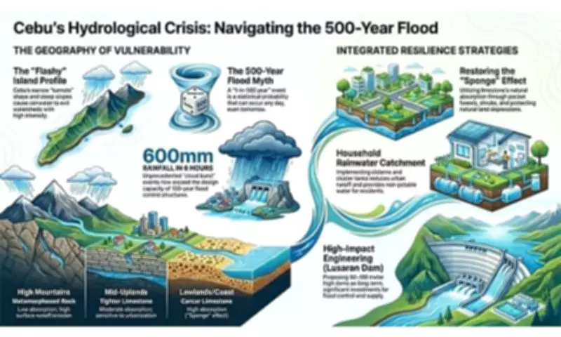
Engineer Maria Nenita Jumao-as, executive director of the University of San Carlos Water Resource Center, describes Cebu as shaped like a "kamote" (sweet potato), bulging at the center and tapering north and south. The island's narrow shape and steep terrain allow rainwater to flow quickly from mountains to coastal areas. "Our floods are flashy because Cebu is a narrow island with steep upland areas. Rainwater flows out very fast, but the flooding is also very intense," she says. Unlike wider islands with large river basins that hold water longer, Cebu's topography causes rainwater to behave like water flowing down a tilted roof, leading to flash floods.
Geology once helped slow runoff. Much of Metro Cebu's coastal area sits on Carcar limestone, a porous rock that absorbs rainwater and recharges groundwater. However, urbanization replaced these areas with roofs and concrete as the metropolis expanded economically, Jumao-as explains. In the uplands, older, harder rock formations absorb far less water. As slopes are cleared and covered with roads and buildings, less rainwater infiltrates the ground, increasing surface runoff. "We replace vegetation with cement," she says.

Flawed Flood-Control Infrastructure
Dr. Danilo Jaque, managing director of HydroNet Consultants Inc., notes that earlier drainage studies recommended wider sections of the Mananga River to handle major floods—about 64 meters wide and five to six meters deep. Today, some sections are only 20 to 25 meters wide. "That will really result in an overflow," he says. He adds that more than half of Metro Cebu's drainage lines are now clogged, further limiting capacity. Jumao-as criticizes some flood-control projects for using generic engineering templates instead of site-specific studies. In one case, the estimated flood volume was three times larger than what a drainage structure was designed to handle. Narrowed river channels and flood-control walls create bottlenecks, forcing water into nearby communities. "Gi-constrict nila... I think that’s the biggest 'no' in current flood-control strategies," she says.
Proposed Solutions
Among the most concerning river systems are the Mananga and Butuanon rivers, which carry huge runoff volumes from the mountains. Jumao-as advocates for large dams 80 to 100 meters high, citing Lusaran as a possible site due to its year-round flow. The Department of Public Works and Highways (DPWH) is studying both large and mini dams for flood control and water supply. Jaque warns that mini dams may not store enough water to significantly reduce downstream flooding, whereas a large dam on the Mananga watershed could hold about 30 million cubic meters—a substantial volume. Beyond infrastructure, Jumao-as urges stronger enforcement of Cebu City's rainwater catchment ordinance, which encourages households to collect and store rainwater for non-drinking uses. "Instead of relying on the ground to absorb rainwater, you capture and store it," she explains.
Conclusion
For hydrologists, Metro Cebu's flooding crisis is no longer just a weather problem. It is a consequence of how the island has been built, engineered, and managed over the years. Unless flood-control planning adapts to Cebu's steep terrain, narrow river systems, and rapid urban growth, communities downstream will continue to face sudden and destructive floods whenever extreme rains hit.