

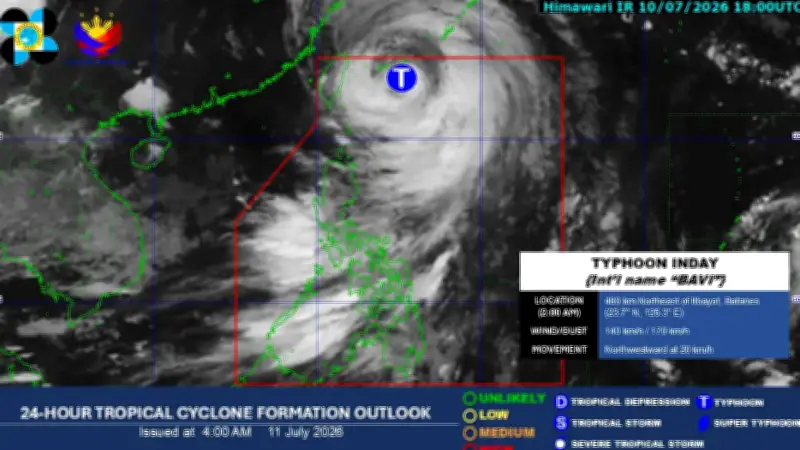
Typhoon Inday, enhanced by the southwest monsoon (Habagat), will bring cloudy skies, rain, and strong winds across much of the Philippines on Saturday, the Philippine Atmospheric, Geophysical and Astronomical Services Administration (PAGASA) announced.
Typhoon Inday's Location and Strength
According to PAGASA's weather bulletin, the center of Typhoon Inday was last spotted 490 kilometers northeast of Itbayat, Batanes. The typhoon packs maximum sustained winds of 140 kilometers per hour near its center, with gusts reaching up to 170 kilometers per hour. It is moving northwestward at a speed of 20 kilometers per hour.
Tropical Cyclone Wind Signals Raised
As a result, Tropical Cyclone Wind Signal No. 2 remains hoisted over Batanes, while Signal No. 1 is in effect over Cagayan, including the Babuyan Islands; Apayao; the northeastern portion of Isabela; and the northern and central parts of Ilocos Norte.

The state weather bureau warned of possible flooding and landslides due to moderate to heavy rainfall, as well as the threat of strong winds that could cause slight to moderate damage to life and property.
Areas Affected by Enhanced Habagat
Meanwhile, the enhanced southwest monsoon will bring occasional rain over Metro Manila, MIMAROPA, Western Visayas, Negros Island Region, La Union, Pangasinan, Benguet, Zambales, Bataan, Cavite, and Batangas.
Over the rest of Mindanao, partly cloudy to cloudy skies with isolated rain showers or thunderstorms are expected.
PAGASA said the typhoon is expected to exit the Philippine Area of Responsibility (PAR) on Saturday morning.