

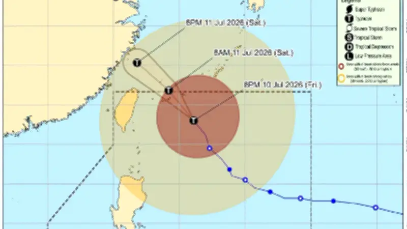
Batanes remains under Signal No. 2 as Typhoon Inday accelerates northwestward, according to the Philippine Atmospheric, Geophysical and Astronomical Services Administration (PAGASA).
Current Typhoon Status
In its 11 PM tropical cyclone bulletin, PAGASA said Batanes will experience strong winds of 62 to 88 kilometers per hour within the next 24 hours. Typhoon Inday packs maximum sustained winds of 140 km/h near the center and gustiness of up to 170 km/h. It is moving northwest at 25 km/h.
The typhoon is expected to exit the Philippine Area of Responsibility (PAR) on Saturday morning, July 11, 2026.

Signal No. 1 Areas
Signal No. 1 is hoisted over the following areas: Cagayan, including Babuyan Islands; northeastern Isabela (Santa Maria, San Pablo, Maconacon, Cabagan, Santo Tomas, Delfin Albano, Tumauini, Ilagan City, Divilacan, and Palanan); Apayao; and northern and central Ilocos Norte (Piddig, Bangui, Vintar, Burgos, Pagudpud, Bacarra, Adams, Pasuquin, Carasi, Solsona, Dumalneg, and Nueva Era).
Under Signal No. 1, these areas may experience winds of 39 to 61 km/h within 36 hours, along with intermittent rains.
Heavy Rainfall Forecast
PAGASA said Zambales, Bataan, Occidental Mindoro, and Antique will experience intense rainfall of 100 to 200 millimeters from Friday evening to Saturday evening. Meanwhile, 50 to 100 mm of rain is expected in Metro Manila, Bulacan, Pampanga, Tarlac, Rizal, Cavite, Laguna, Batangas, Oriental Mindoro, Romblon, Palawan, Aklan, Capiz, Iloilo, Guimaras, Negros Occidental, and Negros Oriental.
Potential Hazards
Due to the heavy rain, flooding is possible in low-lying areas and near rivers, as well as landslides in high-risk areas.