The Philippine state weather bureau has officially confirmed that Severe Tropical Storm Sinlaku, which formed east of the country last week, has completely exited the nation's monitoring domain. This development marks a significant shift in weather patterns affecting the archipelago.
No Direct Impact on Philippine Waters
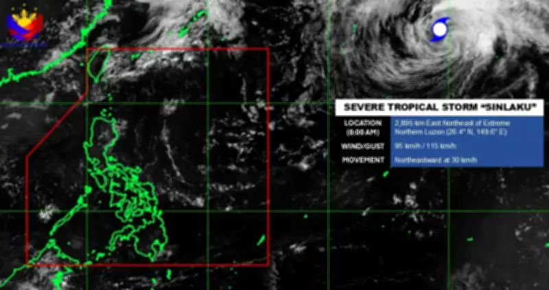
According to meteorological authorities, Sinlaku no longer poses any threat to waters within the Philippine Area of Responsibility. The storm, which previously intensified into a supertyphoon, has moved sufficiently away to eliminate direct risks to domestic maritime zones. However, it continues to exert minor influence on oceanic areas outside the agency's monitoring jurisdiction as it progresses across the Pacific Ocean.
Weather Monitoring Updates
With Sinlaku's departure, the weather bureau reports that there are currently no Low Pressure Areas under observation for potential tropical cyclone development in the coming days. This absence of immediate cyclone threats provides temporary relief for disaster preparedness agencies.

Nevertheless, the Philippines remains under the influence of a persistent High Pressure Area. This weather system continues to affect Extreme Northern Luzon with its broad impact zone. While hot conditions will prevail across most regions, isolated rainshowers and thunderstorms may still occur due to localized atmospheric disturbances.
Regional Weather Implications
Meteorologists emphasize that although Sinlaku has moved beyond Philippine monitoring boundaries, residual effects from its passage combined with the High Pressure Area's dominance create a complex weather scenario. Residents are advised to stay updated with official forecasts as conditions may rapidly change.
The bureau's continuous monitoring ensures timely updates regarding any new weather disturbances that might enter the Philippine Area of Responsibility. Public safety remains the priority as the nation transitions between weather systems.