
The state weather bureau has reported that Tropical Depression Wilma has picked up speed and is now on a path that will bring it ashore over the Eastern Visayas region this weekend.
Current Location and Forecast Track
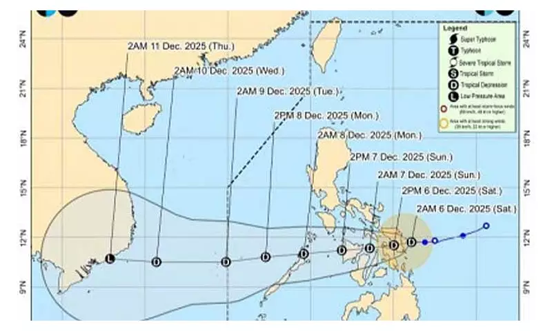
As of 5 a.m. on Saturday, December 6, the Philippine Atmospheric, Geophysical and Astronomical Services Administration (PAGASA) located the center of Wilma approximately 70 kilometers east of Borongan City in Eastern Samar. The tropical depression is carrying maximum sustained winds of 45 kilometers per hour near its center, with gusts reaching up to 55 kph. It is currently moving in a westward direction at a pace of 15 kph.
PAGASA forecasts that Wilma will maintain a generally westward trajectory for most of its path. The weather disturbance is expected to make its initial landfall over Eastern Visayas sometime on Saturday. Following this, it will continue to move across the Visayas islands throughout Sunday. The system is then predicted to emerge over the Sulu Sea and could pass over the northern part of Palawan by Monday morning. Wilma is likely to remain a tropical depression as it crosses the Visayas and Southern Luzon.

Areas Under Tropical Wind Signal No. 1
In anticipation of the cyclone's effects, PAGASA has hoisted Tropical Cyclone Wind Signal (TCWS) No. 1 over numerous areas. This signal indicates that winds of 39 to 61 kph may be expected within the next 36 hours.
In Luzon, the following are under Signal No. 1:
- Sorsogon
- Masbate, including Ticao and Burias Islands
- Romblon
- Southern portions of Oriental Mindoro (Bulalacao, Mansalay, Roxas, Bongabong)
- Southern portions of Occidental Mindoro (Magsaysay, San Jose, Rizal, Calintaan)
- Northernmost portion of Palawan (Araceli, Dumaran, El Nido, Taytay) including Cuyo, Calamian, and Cagayancillo Islands
In the Visayas, a wide area is under the signal:
- Northern Samar, Eastern Samar, Samar, Biliran, Leyte, Southern Leyte
- Cebu including Bantayan and Camotes Islands
- Bohol, Negros Occidental, Siquijor
- Northern and central Negros Oriental (multiple cities and municipalities listed)
- Guimaras, Iloilo, Capiz, Aklan, Antique
In Mindanao, affected areas include:
- Surigao del Norte, including Siargao and Bucas Grande Islands
- Dinagat Islands
- Northern portion of Surigao del Sur (Carrascal, Cantilan, Madrid, Carmen, Lanuza)
- Northern portion of Agusan del Norte (Kitcharao, Jabonga, Santiago, Tubay, City of Cabadbaran, Remedios T. Romualdez, Magallanes)
- Camiguin
Weather Impacts and Hazards
PAGASA warns that rains accompanied by gusty winds will be experienced over the Visayas, Romblon, Masbate, Sorsogon, Camiguin, Surigao del Norte, Surigao del Sur, Agusan del Norte, and Dinagat Islands due to the influence of Wilma.
Meanwhile, a separate weather system, the shear line, is forecast to bring scattered rains and isolated thunderstorms over the rest of the Bicol Region, Quezon, Occidental Mindoro, Oriental Mindoro, and Marinduque.
The combined effects of these systems raise the threat of flash floods and landslides in areas affected by moderate to heavy, and at times intense, rainfall. Residents in these localities are advised to take necessary precautions and monitor updates from official sources.
Other parts of the country will experience varied conditions. The Zamboanga Peninsula, the rest of Caraga, and the rest of Northern Mindanao will have scattered rains and thunderstorms due to Wilma. Cagayan Valley, the Cordillera region, and Aurora will experience rains brought by the northeast monsoon or 'amihan'. The rest of the Philippines can expect partly cloudy to cloudy skies with isolated light rains.
Mariners are cautioned about sea conditions. Northern Luzon and the eastern sections of Central and Southern Luzon will have strong to gale-force winds and rough to very rough coastal waters. The western section of Mindanao, the rest of Luzon, and the rest of the Visayas will experience moderate to strong winds and moderate to rough seas. The rest of Mindanao will have moderate winds and moderate seas.


