
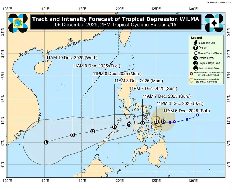
The state weather bureau continues to monitor Tropical Depression Wilma as it lingers off the coast of Eastern Samar on Saturday, December 6, 2025. The cyclone has maintained its strength and poses a threat of making landfall within the day.
Current Location and Forecast Track
As of the 2 p.m. weather bulletin, the center of Wilma was located approximately 65 kilometers east-northeast of Borongan City, Eastern Samar. The weather disturbance was nearly stationary but is predicted to start moving in a westward direction. Pagasa forecasts that Wilma may make its initial landfall over Eastern Samar or Northern Samar late Saturday.
Following landfall, the tropical depression is expected to cross the Visayas region throughout Sunday. Its projected path will then take it over the Sulu Sea, passing close to northern Palawan by Monday.

Intensity and Potential Impacts
Wilma currently packs maximum sustained winds of 45 kilometers per hour (kph) near its center, with stronger gusts reaching up to 55 kph. While it is forecast to remain a tropical depression, meteorologists note that dry air associated with the northeast monsoon could cause it to weaken into a remnant low while traversing the central islands.
Despite this, Tropical Cyclone Wind Signal (TCWS) No. 1 is currently hoisted over numerous areas, indicating that strong winds are imminent. Residents in the following localities should prepare for minimal to minor wind impacts:
- Luzon: Sorsogon, Masbate, Romblon, parts of Mindoro and Palawan.
- Visayas: Northern Samar, Eastern Samar, Samar, Biliran, Leyte, Cebu, Negros Island, Iloilo, Capiz, Aklan, and Antique.
Additional Hazards and Warnings
Pagasa emphasized that the effects of Wilma, including heavy rainfall and severe winds, may still be felt in areas outside the predicted track. The public is advised to remain vigilant.
Compounding the situation, the northeast monsoon is enhancing conditions across a wider area. Strong to gale-force gusts are anticipated over most of Luzon, the Visayas, and the Zamboanga Peninsula until Monday.
A critical gale warning remains in effect for the eastern seaboards of Luzon and the Visayas. Sea conditions are very rough to hazardous, with wave heights potentially soaring up to 5.5 meters in some areas. Pagasa considers sea travel risky for all types of vessels. Mariners are strongly advised to stay in port or seek safe harbor until weather and sea conditions improve significantly.


