Tropical Depression Basyang Poses Significant Threat to Visayas Region
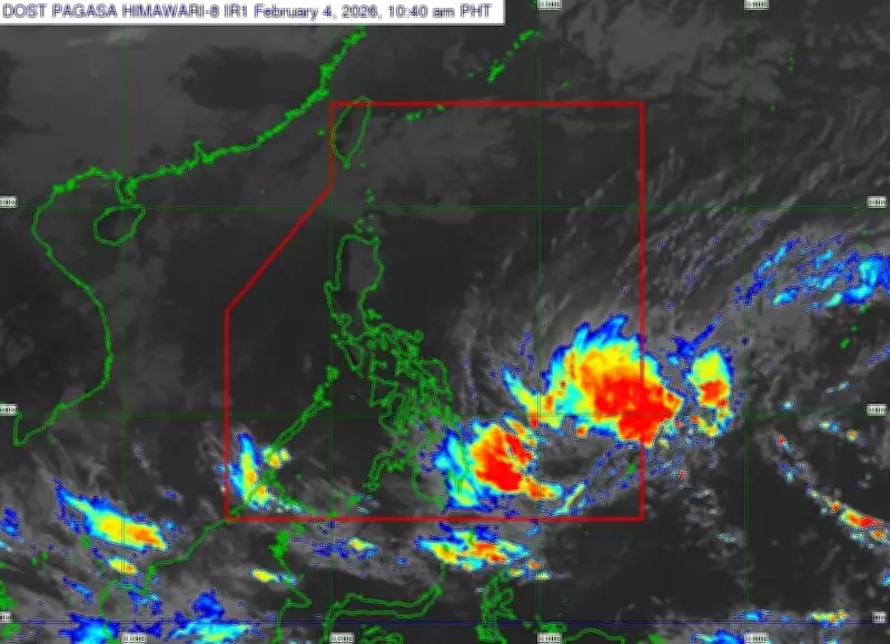
The Philippine Atmospheric, Geophysical and Astronomical Services Administration (Pagasa) Visayas has issued a critical weather alert regarding Tropical Depression Basyang, which entered the Philippine area of responsibility on Wednesday, February 4, 2026. According to Pagasa Visayas Chief Weather Forecasting Specialist Jhomer Eclarino, the weather system was last positioned approximately 735 kilometers east of Surigao del Sur and continues to be monitored closely.
Potential Intensification and Landfall Projections
During an interview conducted in Cebuano, Eclarino emphasized that Basyang remains a tropical depression but retains the potential to strengthen into a tropical storm before making its initial landfall over Eastern Mindanao. This development could significantly increase the system's impact, bringing more intense rainfall and stronger winds to affected regions.
Based on the latest forecast track analysis, the center of Basyang is projected to move toward the southern portions of Central Visayas. This trajectory suggests that provinces including Cebu and surrounding areas could experience the weather system's effects by Friday, February 6. However, Eclarino cautioned that due to the inherent cone of uncertainty associated with tropical cyclones, Basyang's actual path may still shift either northward or southward as it approaches land.

Expected Rainfall and Wind Impacts
Pagasa's weather advisory indicates concerning precipitation levels for the region. Cebu province is forecast to receive rainfall ranging from 50 to 100 millimeters, while certain areas across the province could experience even heavier rainfall of up to 100 to 200 millimeters. Eclarino warned that this expected rainfall is classified as heavy and potentially dangerous, particularly for communities situated in flash flood- and landslide-prone zones, including those living near rivers and creeks.
The weather agency is also preparing for the possible raising of Tropical Cyclone Wind Signals in parts of Central Visayas as Basyang approaches. Should wind signals be elevated, strong winds could potentially damage light structures and agricultural areas throughout the affected provinces.
Precautionary Measures and Regional Concerns
Pagasa Visayas continues to monitor Basyang's development and movement closely, with regular updates expected as the situation evolves. Residents in potentially affected areas, particularly in Central Visayas and Eastern Mindanao, are advised to:
- Stay informed through official Pagasa weather bulletins
- Prepare for possible evacuation if living in flood- or landslide-prone areas
- Secure loose outdoor items that could become projectiles in strong winds
- Monitor water levels in nearby rivers and creeks
The approaching weather system serves as a reminder of the Philippines' vulnerability to tropical cyclones, particularly during weather patterns that bring systems toward the Visayas and Mindanao regions. Pagasa's ongoing monitoring aims to provide timely information to help communities prepare for Basyang's potential impacts.