Tropical Depression Intensifies Outside Philippine Waters, May Enter PAR Within Days
A low pressure area (LPA) that has been under observation outside the Philippine Area of Responsibility (PAR) has now officially developed into a tropical depression. According to the Philippine weather bureau, although the system remains outside the country's monitoring zone, authorities are continuously tracking its movement as it could potentially affect weather conditions in the coming days.
Current Strength and Projected Path
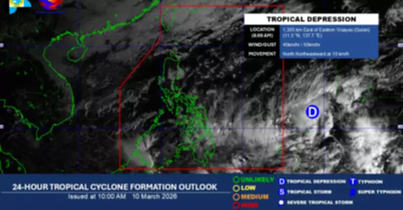
Based on the latest meteorological data, the tropical depression currently exhibits maximum sustained winds of 45 kilometers per hour near its center, with gusts reaching up to 60 kilometers per hour. The weather disturbance is forecast to move in a west-northwest direction, with a high probability of entering the Philippine Area of Responsibility within one to two days.
Once it crosses into Philippine territory, the tropical depression will be assigned a local name according to the official storm naming list for the current year. This standard procedure helps facilitate clear communication and public awareness during weather events.

Public Advisory and Monitoring
Weather experts have strongly advised the public to remain vigilant and stay updated through official announcements from authorized agencies. They have cautioned against relying on unverified information circulating through unofficial channels, which could lead to confusion and improper preparedness measures.
The Philippine Atmospheric, Geophysical and Astronomical Services Administration (PAGASA) emphasized that "continuous monitoring is essential as weather systems can change rapidly, and early preparation is key to minimizing potential impacts."
Early Storm Activity Indication
Meteorologists have noted that the formation of this tropical depression outside the PAR during early March represents unusual storm activity for this time of year. Typically, the Philippines experiences increased tropical cyclone activity beginning in mid-June, making this development noteworthy for climate observers.
This early formation could signal:
- An earlier start to the typhoon season than usual
- Potential changes in regional weather patterns
- The need for earlier preparedness measures by communities
Weather authorities will continue to provide regular updates as the tropical depression progresses, with special attention to its potential entry into Philippine waters and any subsequent development into a stronger weather system.