
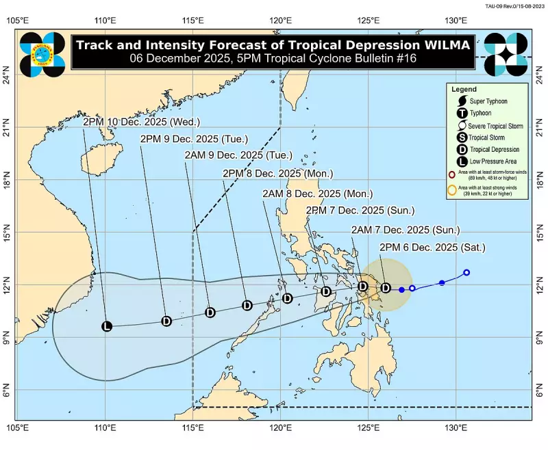
The Philippine Atmospheric, Geophysical and Astronomical Services Administration (Pagasa) reports that Tropical Depression Wilma has maintained its strength while hovering near the coast of Eastern Samar this Saturday afternoon, December 6, 2025.
Current Location and Forecast Track
As of the 5 p.m. weather bulletin, the cyclone's center was located over the coastal waters of Can-avid in Eastern Samar. Wilma is packing maximum sustained winds of 45 kilometers per hour (kph) near its center, with gusts reaching up to 55 kph. The weather disturbance has shown little movement since midday but is projected to make landfall over Eastern Samar or Northern Samar between late afternoon and evening today.
The state weather bureau forecasts that Wilma will cross the Visayas region throughout Sunday. It is then expected to emerge over the Sulu Sea by Monday, moving toward northern Palawan. Pagasa notes that the system will likely remain a tropical depression during its passage, though the intrusion of dry air from the northeast monsoon or 'amihan' could weaken it into a remnant low while over the Visayas.

Areas Under Wind Signal and Hazards
Tropical Cyclone Wind Signal (TCWS) No. 1 remains hoisted over extensive areas of Luzon and the Visayas. Residents in the following localities should prepare for potential minimal to minor wind impacts:
- Sorsogon, Masbate, Romblon, parts of Mindoro, and northern Palawan
- The entire Samar provinces (Northern Samar, Eastern Samar, Samar), Biliran, and Leyte
- Cebu, Negros Island, Guimaras, Iloilo, Capiz, Aklan, and Antique
Pagasa also cautioned that even areas outside the wind signals may experience strong to gale-force gusts due to the enhanced northeast monsoon. This is particularly likely over most of Luzon, the Visayas, and the Zamboanga Peninsula through Monday.
Rough Seas and Gale Warning
A gale warning is currently in effect for the northern and eastern seaboards of Luzon. Sea conditions in these areas are forecast to be very rough, with wave heights potentially reaching up to five meters. This poses a significant risk to all types of sea vessels.
Rough to very rough seas are also expected to persist over the seaboards of Eastern Samar, Northern Samar, and several other coastal provinces in Luzon and Mindanao. Mariners are strongly advised to remain in port or seek safe harbor immediately.
Next Expected Positions
Pagasa provided the following anticipated positions for Wilma:
- Over Samar by early Sunday, December 7.
- Over the coastal waters of Aklan by Sunday afternoon.
- In the vicinity of Linapacan, northern Palawan, by early Monday, December 8.
- Near Pag-asa Island in the West Philippine Sea by Tuesday, as it moves out of the Philippine Area of Responsibility (PAR).
The public, especially those in the affected regions, are urged to continue monitoring updates from Pagasa and follow instructions from local disaster authorities.


