
Typhoon Uwan Gains Strength as it Nears Philippine Landmass
The Philippine Atmospheric, Geophysical, and Astronomical Services Administration (Pagasa) reported that Typhoon Uwan continues to rapidly intensify while moving closer to the Philippine territory. Several areas in Mindanao are already experiencing the typhoon's effects as of Sunday, November 9, 2025.
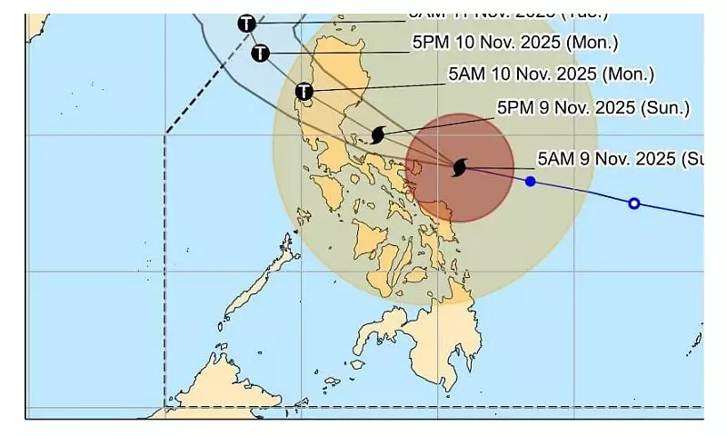
According to Pagasa's 5 a.m. advisory, the typhoon is projected to make landfall by Sunday evening or early Monday, with forecasters warning that storm surges may reach up to three meters in vulnerable coastal communities.
Areas Under Tropical Cyclone Wind Signals
Pagasa has placed multiple regions under Tropical Cyclone Wind Signal No. 1, including:

- Dinagat Islands
- Surigao del Norte
- Northern portion of Agusan del Norte (Tubay, Santiago, Jabonga, Kitcharao)
- Northern areas of Surigao del Sur (Carrascal, Cantilan, Madrid, Carmen, Lanuza, Cortes)
The weather bureau noted that Uwan, known internationally as Fung-Wong, is likely to track west-northwest through the weekend before turning more northward on Monday.
Projected Path and Intensity
Pagasa indicated that the eye of the storm may pass very close to Catanduanes and could make landfall over the southern part of Isabela or the northern portion of Aurora by Sunday evening or early Monday morning, November 10.
The agency also cautioned that the typhoon's path may shift slightly, which could result in a direct hit or landfall over Catanduanes. As of Sunday morning, Pagasa raised Tropical Cyclone Wind Signal No. 5 in several Luzon areas after Uwan reached super typhoon status.
Weather experts warned that Uwan is expected to make landfall at or near peak intensity and may weaken as it crosses Northern Luzon due to mountainous terrain, but is expected to remain a typhoon throughout its passage.
Extended Forecast and Warnings
The typhoon may exit the Philippine Area of Responsibility by Tuesday, briefly re-enter the northwestern boundary on Thursday as it crosses Taiwan, and fully exit by Friday morning.
A gale warning remains in effect over the seaboards of Northern and Central Luzon, eastern and southern portions of Southern Luzon, eastern and central Visayas, and the eastern coast of Mindanao.
Authorities continue to urge residents, especially those in coastal and low-lying areas, to stay alert and monitor official weather updates from Pagasa as the situation develops.


