

The southwest monsoon, locally known as Habagat, has officially begun, marking the start of the country's rainy season, according to the Philippine Atmospheric, Geophysical and Astronomical Services Administration (Pagasa).
Weather Outlook for Cebu and Central Visayas
Pagasa Visayas weather specialist Ever John Tenio said Sunday, May 31, 2026, that Cebu and the rest of Central Visayas will experience generally fair and hot weather because the rainy season has just begun. Tenio added that the region is likely to see partly cloudy to cloudy skies, with warm and humid conditions prevailing while localized thunderstorms remain possible.
Monsoon Dynamics
“Usually, kining si southwest monsoon predominantly iyang maapektahan is kani dinhi sa western section sa nasud. But in cases na ma-enhance ni siya so naay mga tendencies na muabot ang impact ani ni southwest monsoon sa may Central Visayas,” said Tenio. The weather specialist explained that the monsoon's impact can extend to Central Visayas, including Cebu, when enhanced by a tropical cyclone over the northeastern part of the country or within the Philippine Area of Responsibility (PAR). Such weather systems typically bring cloudy skies and widespread rainfall throughout the day. Pagasa officially announced the onset of Habagat on Saturday, May 30.

Typhoon Domeng
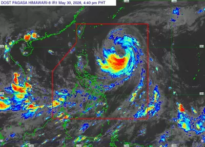
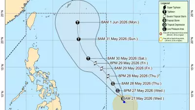
Meanwhile, typhoon Domeng maintained its strength Sunday as it moved north-northwest over the Philippine Sea, east of Batanes. The storm continues to enhance the southwest monsoon, which is expected to bring rains and strong winds across large parts of the country. In its 5 a.m. bulletin, Pagasa stated that typhoon Domeng was located 670 kilometers east of Basco, Batanes, packing maximum sustained winds of 120 kilometers per hour (kph) near the center and gusts of up to 150 kph. The typhoon was moving north-northwest at 20 kph and is forecast to continue on the same track before recurving toward southern Japan. It will likely exit the PAR by Sunday afternoon without making landfall in the country.
Regional Weather
No Tropical Cyclone Wind Signal has been raised over any part of the country, and Pagasa noted that hoisting wind signals over extreme northern Luzon is now less likely. Despite remaining far from land, typhoon Domeng continues to enhance the southwest monsoon, bringing rains over the western sections of the country, including Metro Manila, Calabarzon, Mimaropa, Bicol Region, Western Visayas, Negros Island Region, Zamboanga Peninsula and the Bangsamoro Autonomous Region in Muslim Mindanao. The trough of the typhoon is also expected to bring rain showers over parts of Central Luzon, Cagayan and Isabela. Pagasa warned that strong to gale-force gusts may affect Metro Manila, Calabarzon, Mimaropa, Bicol Region, much of the Visayas and several areas in Mindanao through the next few days.
Precautionary Measures
Forecasters are also watching for the possible development of a low-pressure area through Wednesday, June 3, alongside another potential weather disturbance over Western Luzon from Thursday, June 4, to June 10. Tenio said Central Visayas is unlikely to experience direct effects from these weather systems given their current positions. He added that rainfall in the region during the first week of June will most likely be driven by localized thunderstorms. Sea travel remains risky in northern Luzon waters, particularly along the coasts of Batanes, Babuyan Islands, Cagayan and Isabela, because of rough sea conditions. Pagasa advised residents in areas vulnerable to flooding, landslides and strong winds to remain alert, stay updated on weather advisories and monitor localized thunderstorms even during periods of fair weather.