The Department of Science and Technology’s Philippine Institute of Volcanology and Seismology (DOST-Phivolcs) has clarified that the magnitude 7.8 earthquake that struck offshore Sarangani on June 8, 2026, is purely tectonic in origin and is not expected to trigger volcanic activity in nearby volcanoes.
Earthquake Details and Origin
In its earthquake primer released on the same day, DOST-Phivolcs stated that the powerful tremor originated 32 kilometers west of Maasim, Sarangani, at a depth of 33 kilometers. The agency explained that the quake was likely caused by subduction-related movement along the Cotabato Trench, one of the country's major earthquake-generating structures.
Despite the strength of the earthquake, Phivolcs emphasized that there is no indication of any connection to volcanic unrest. The agency noted that while the nearest active volcanoes to Sarangani are Matutum and Parker Volcanoes, the event is tectonic. However, in line with standard monitoring protocols for moderate to great earthquakes occurring near active volcanoes, Phivolcs will continue to closely monitor the area for any volcanic activity that may be affected by the event.

Seismic Activity and Aftershocks
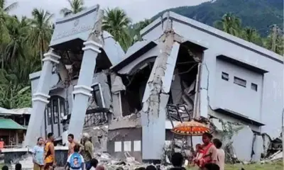
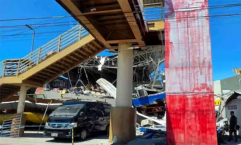
The earthquake struck at 7:37 a.m. on June 8 and generated widespread shaking across Mindanao. The highest recorded intensity reached PEIS VII (Destructive) in General Santos City, while weaker tremors were felt as far as Leyte. As of 7 a.m. on June 9, Phivolcs recorded 1,055 aftershocks with magnitudes ranging from 1.3 to 6.7. Of these, 301 aftershocks had been located, and 21 were felt in affected communities.
Tsunami and Secondary Hazards
Phivolcs confirmed that the offshore quake generated tsunami waves along portions of Sarangani and Sultan Kudarat. Sea level monitoring stations recorded waves of about one meter in Kiamba, Maasim, and Kalamansig, while smaller wave disturbances were observed in Mati City and Zamboanga City. The tsunami warning issued shortly after the earthquake was later lifted after monitoring showed no damaging waves.
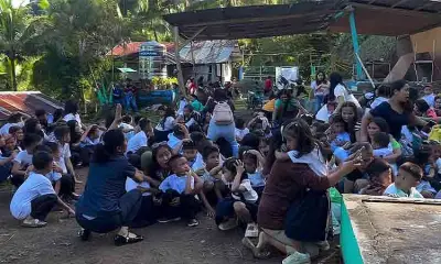
The agency warned communities to remain alert for secondary hazards such as landslides, rockfalls, liquefaction, ground fissures, and coastal inundation, particularly in low-lying and water-saturated areas. Residents were urged to avoid damaged structures until cleared by engineers, inspect slopes for cracks that could lead to landslides, and stay vigilant for natural tsunami warning signs such as strong ground shaking, sudden changes in sea level, or unusual roaring sounds from the ocean.
Official Advisories and Safety Reminders
Phivolcs reminded the public to rely only on official advisories from government authorities and avoid spreading unverified information as response and recovery efforts continue in areas affected by the earthquake. The agency reiterated that strong earthquakes occurring near active volcanoes are routinely monitored to determine whether seismic activity could influence volcanic systems, but based on current observations, no volcanic activity associated with the earthquake has been detected.
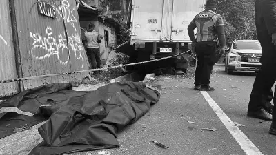
Reports indicate at least 37 deaths and hundreds injured, with commercial establishments and infrastructure sustaining major damage in General Santos City and other areas.