MANILA - The Philippines braces for another weather disturbance as Tropical Storm Tino has intensified into a severe tropical storm, with weather authorities warning it could reach typhoon strength before making landfall.
According to the Philippine Atmospheric, Geophysical and Astronomical Services Administration (PAGASA), Tino continues to gain momentum as it moves across Philippine waters. The storm's rapid development has prompted immediate weather advisories across affected regions.
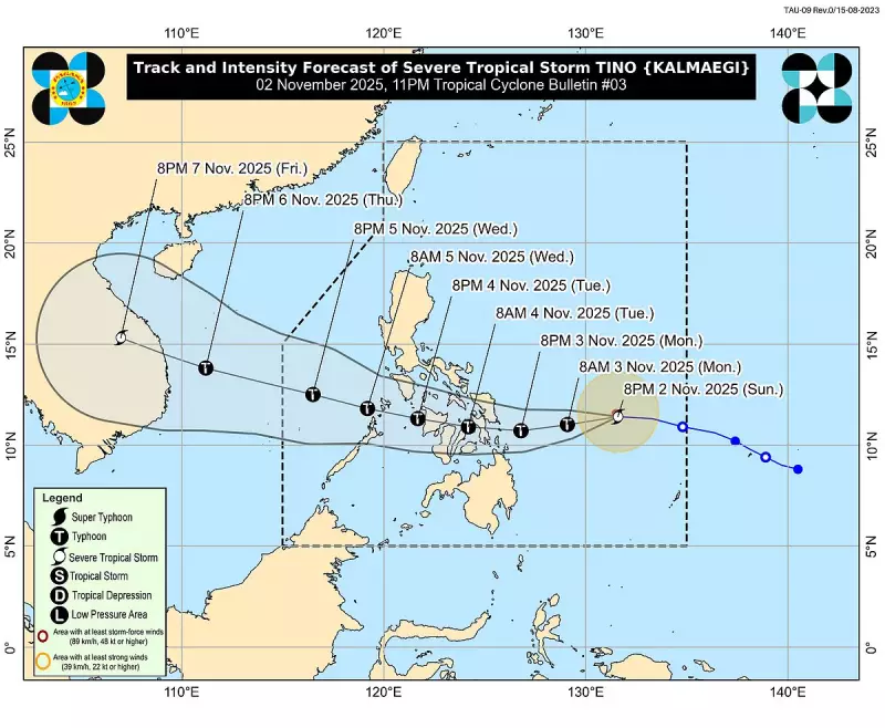
Current Storm Status and Projected Path
As of the latest bulletin, Tino was tracked moving westward, packing maximum sustained winds of 95 kilometers per hour near the center and gustiness reaching up to 115 kilometers per hour. The storm is expected to maintain its current trajectory, potentially affecting several key areas in the coming hours.

Weather specialists note that the favorable atmospheric conditions, including warm sea surface temperatures, provide the necessary fuel for Tino's continued intensification. The storm is projected to reach typhoon category within the next 12 to 24 hours.
Areas Under Warning Signals
PAGASA has raised Tropical Cyclone Wind Signals over multiple provinces, with the following areas placed under alert:
- Signal No. 1: Northern Samar, Eastern Samar, and surrounding coastal areas
- Signal No. 2: Expected to be raised as the storm approaches land
- Additional regions may be included as Tino progresses
Residents in low-lying and mountainous areas are advised to take precautionary measures against possible flooding and landslides.
Potential Impacts and Precautionary Measures
The weather bureau anticipates several hazardous conditions developing in the storm's path:
- Heavy Rainfall: Moderate to heavy rains expected within the 300-kilometer diameter of the storm
- Strong Winds: Increasing wind strength posing risks to structures and transportation
- Coastal Conditions: Rough sea conditions with waves reaching several meters high
Local government units have been alerted to prepare evacuation plans, especially for communities in flood-prone and landslide-susceptible areas. The Office of Civil Defense has coordinated with regional disaster risk reduction management councils to ensure rapid response capabilities.
Maritime and Transportation Advisories
Sea travel remains risky for most vessels in the northern and eastern seaboards. Several domestic flights have been preemptively canceled, with airlines advising passengers to monitor their flight status regularly.
Fisherfolk and those with small seacraft are strongly advised to remain in port or seek safe harbor until the storm passes and sea conditions improve.
Weather updates will be provided regularly as PAGASA continues to monitor Tino's development and movement. Residents in affected areas are encouraged to stay tuned to official weather bulletins and follow instructions from local authorities.